NASA and United Launch Alliance are preparing to launch a Northrop Grumman-built spacecraft in mid-September on a mission to record the changing measurements of Earth’s glaciers, ice sheets and sea ice.
The Ice, Cloud and land Elevation Satellite-2 is scheduled to lift off Sept. 15 at Vandenberg Air Force Base on the final launch of ULA’s Delta II rocket, the space agency said Wednesday.
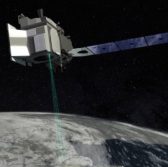
ICESat-2 is designed to measure the planet’s changing terrain through 10,000 laser pulses per second.
The satellite will use its Advanced Topographic Laser Altimeter System payload to record the speed of laser pulses and determine the distance between the spacecraft and Earth’s surface.
Northrop designed and manufactured the spacecraft, as well as integrated the payload and tested the system of the completed observatory platform.
NASA’s Goddard Space Flight Center oversees the development and assessment process of the ICESat-2 program and ATLAS instrument.


