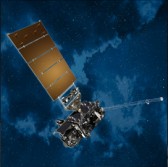
 Harris Corp. will hand over the fourth Advanced Baseline Imager for integration with the National Oceanic and Atmospheric Administration’s Geostationary Operational Environmental Satellite after the company completed a pre-ship assessment of ABI with NASA and NOAA.
Harris said Tuesday the ABI instrument is scheduled to fly aboard the GOES-U spacecraft in 2024 and will work to capture Earth images within five minutes in order to help forecast thunderstorms, fires, hurricanes and other weather conditions.
Eric Webster, vice president of Harris environmental solutions business, said ABI is designed to track thunderstorms approximately 22,300 miles away from Earth within seconds.
Harris noted it built a total of seven ABIs for the U.S., South Korea and Japan as well as the ground-based command-and-control system for the GOESÂ weather satellite series.
The company said it expects the first GOES-R satellite with the ABI to take off on Nov. 4 from Cape Canaveral in Florida followed by GOES-S in 2018 and GOES-T in 2019.


