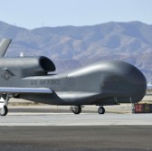
 The National Oceanic and Atmospheric Administration will use a Northrop Grumman-built unmanned aerial system to carry out missions that aim to study El Nino-related weather conditions over the Pacific Ocean.
NOAA will utilize NASA’s Global Hawk UAV for the Sensing Hazards with Operational Unmanned Technology missions that will take place starting this month through March, Northrop said Friday.
Scientists at NOAA will launch the drone with aerial, sea and ground platforms to collect meteorological measurements and use the data to improve the agency’s storm predictions and observational models and related systems.
Dave Aguinaldo, NASA Global Hawk program manager at Northrop, said the drone is designed to fly for 30 hours at an altitude of up to 65,000 feet and will work to help NOAA study remote weather patterns.
Northrop and NASA permit the shared use of the UAV for scientific experiments and other missions through the Space Act Agreement.


