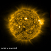
 The National Oceanic and Atmospheric Administration has unveiled the first images from two Lockheed Martin-built space instruments onboard a weather monitoring satellite that was launched in November last year.
Lockheed said Monday the Geostationary Lightning Mapper and Solar Ultraviolet Imager on NOAA’s Geostationary Operational Environmental Satellite-16 work to record continuous lightning data and compile complete views of the sun, respectively.
Jeff Vanden Beukel, director of GOES-R instruments at Lockheed, said data from the GLM and SUVI platforms will support warning and weather prediction for potential disaster strikes.
Northrop Grumman developed the High Efficiency Cryocooler system on the GOES-16 satellite to cool a Harris-built Advanced Baseline Imager that serves as the satellite’s primary instrument.
The HEC system comprises a pulse tube cryocooler and cryocooler control electronics designed to manage temperature in ABI’s infrared detectors and optics, Northrop said Monday.
GOES-16 lifted aboard a United Launch Alliance-built Atlas V rocket from Cape Canaveral, Florida, in November.


