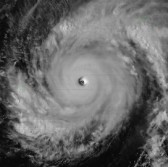
 Japan’s national weather agency has used an Exelis imaging instrument on the Himawari-8 weather satellite to collect weather and environmental images such as Typhoon Maysak and the clouds and snow around Mount Fuji.
The company said Friday the imager works to support the satellite’s weather forecasting and tracking, fire detection, air pollution analysis, vegetation assessment and volcanic ash monitoring operations.
Eric Webster, vice president and director of Exelis’ environmental intelligence unit, said the images and video collected by Himawari-8 build on the functinos of the previous Multifunctional Transport satellite or MTSAT-2.
Himawari-8 captures color images every 10 minutes to provide more details to support decision-making compared to MTSAT-2’s hourly monochrome images.
The company noted that it will provide one other satellite imager to Japan.


