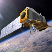
 The National Oceanic and Atmospheric Administration‘s Joint Polar Satellite System, designed to support weather forecasting, has achieved operational status after completing a series of tests.
Known as JPSS-1 before it reached orbit, the NOAA-20 satellite features multiple instruments built to gather data on Earth’s atmosphere, land and waters, the agency said Wednesday.
The Ball Aerospace-built satellite was launched in November aboard United Launch Alliance‘s Delta II rocket.
“NOAA-20 is especially beneficial for tracking developing storms in the Arctic, Alaska and Antarctica,” said Neil Jacobs, assistant secretary of commerce for environmental observation and prediction.
“Forecasts for these remote regions are critical for the U.S. fishing, energy, transportation and recreation industries, which operate in some of the harshest conditions on the planet.”
NOAA noted its National Weather Service will use global data from NOAA-20 in efforts to create weather prediction models that can support forecasts.
The satellite includes the Visible Infrared Imaging Radiometer Suite designed to identify and visualize initial stages of fog, sea-ice formation and breaking, volcanic eruptions and wildfires.


