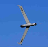
 Boeing‘s Insitu subsidiary, FireWhat and Esri have partnered with the goal to help firefighters put out wildfires through aerial reconnaissance support.
The alliance seeks to integrate Insitu’s INEXA Solutions aerial remote sensing services with FireWhat’s geographic information system hosted on Esri’s ArcGIS mapping platform, Insitu said Thursday.
The integrated system will work to deliver near-real time, web-based video feed of thermal images to FireWhat’s mobile command centers on the ground.
Jon Damush, vice president and general manager of Insitu’s commercial business, said the combined offering is designed to eliminate fire line information lag time that typically reaches 12 to 24 hours due to darkness and smoke.
Insitu’s INEXA product suite includes the INEXA Control ground control station; unmanned aerial vehicles such as ScanEagle; and payloads like the High Accuracy Photogrammetry aerial survey platform.
HP will also provide hardware including servers, laptops and printers to the collaborative effort, Insitu noted.


